Wednesday, November 9, 2011

A Garden Tour: Pied-à-Terre

Pied-à-terre is a french expression that literally means "feet to the ground", but linguistically refers to a small city dwelling that is like a home-away-from-home, more than likely used perodically to ease longer distance commuting during the work week. The expression can be generally applied to any second home or getaway. So, such is the moniker we chose for our house in Orange. Rewind to 1985: when my father retired from teaching at OCHS he and mom were still living in the Main Street house on the corner of Landon Lane where I lived as a high schooler and summer resident during my college days. They had a relationship with an elderly lady  down the street who was in a nursing home. Her desire had been for her house to pass on to them at her death but she sped up the process (not dying but the transfer of the house) and my folks moved in about a year later. Since then our family has enjoyed many memorable events there, one of particular note was the reception following the marriage of the youngest which took place in the garden in the back of the house. The family has diminished over time due to age and illness and now M and I are the sole proprietors and still enjoying place. 
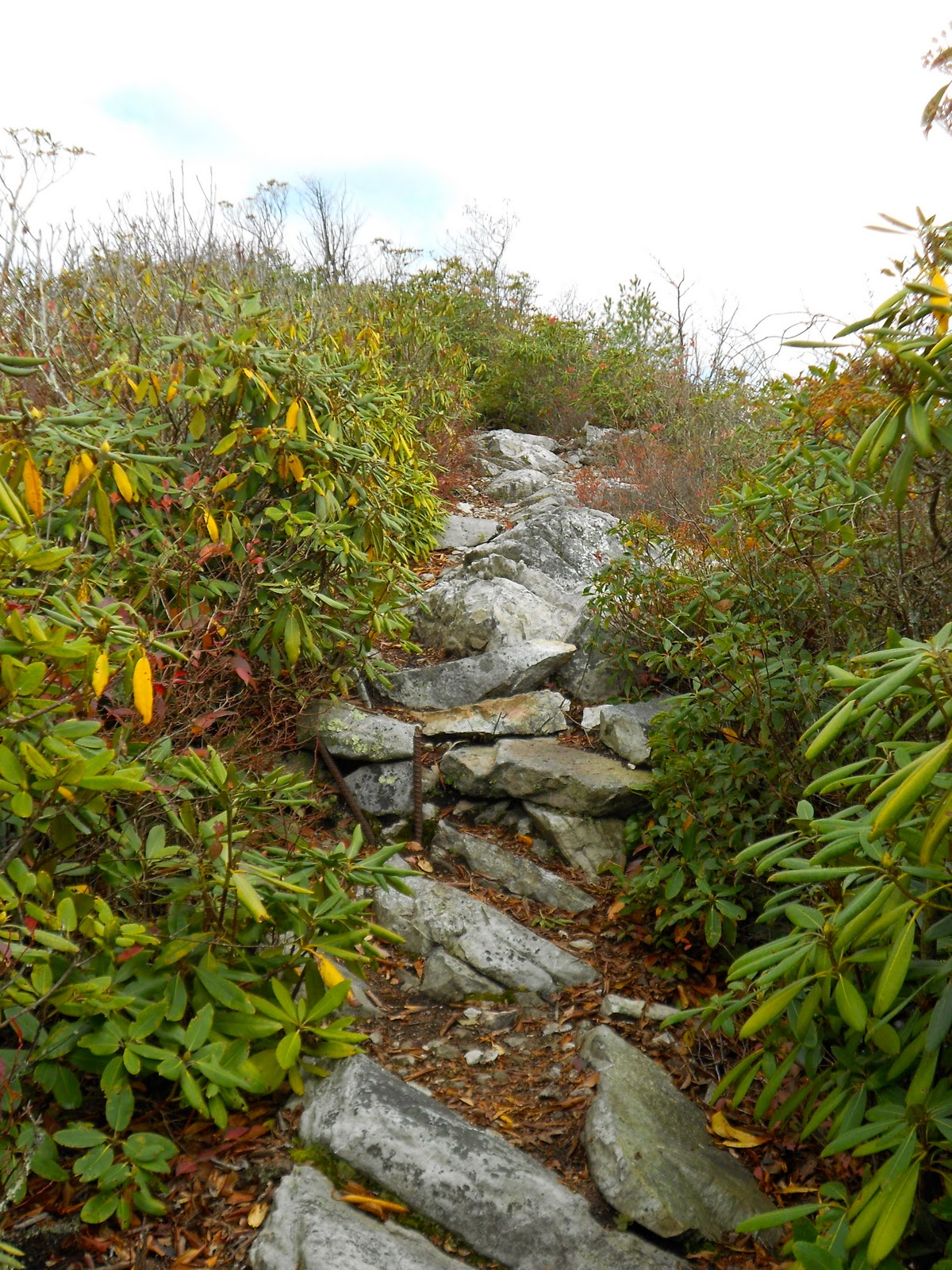
A dear friend and I were standing out back the other evening and she commented on the beauty of the view and how the back porch was arranged. When I am there alone I usually work like a Trojan and miss those beautiful moments, but two days later, I was mowing the 2 acres of lawn, most of which is in the back arranged in a set of three descending terraces and beyond them what we lovingly call the "lower 40." The angle of the sun cast remarkable shadows so when I finished I was compelled to capture this particular moment. The photos came out OK for an amateur so why not share them? Following is a sequence of pictures beginning on the steps of the back porch, and proceeding down through the center boxwoods, the terraces, the lower 40, and then back up the south lane around the terraces to the shop and house.


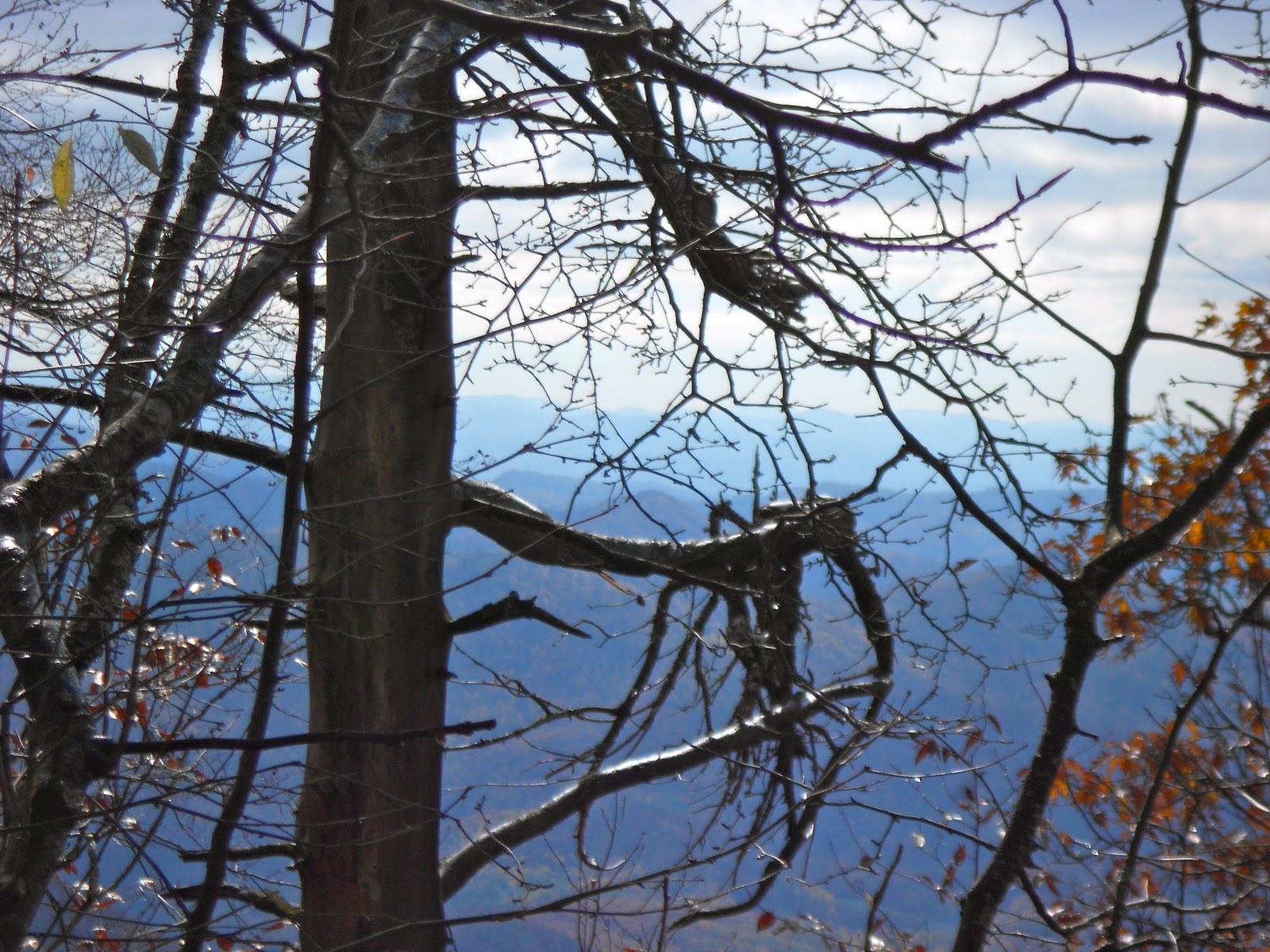
The last picture is "Papa's Shop". When mom and dad moved in it was a small garage at the end of the drive and my dad converted into his workshop by adding the ell to the right in place of the garage door and the porch in front with the curved roof. You may have noticed (go back if you missed it) the same curved roofline on the back porch which my folks also added so they could sit and enjoy the view. Many a leisurely hour has passed on that porch and scads of friends have been entertained there as well. The ever-present hill viewed from west to east from the back is appropriately called "Henry's Hill", or at least as far as those who did the porch sitting were concerned. My mom and dad loved that view and never let the spell of a beautiful moment escape them. I have some practicing to do.

Tuesday, October 25, 2011

New Trail: Allen Gap to Devil's Fork Gap

Date:  October 21, 2011
Where: Tennessee - North Carolina Border near Hot Springs
Weather: Mostly sunny, 40s to start, breezy, pleasant in the afternoon
Length: 20.2 m
Elevation change: Allen Gap - 2200' to Camp Ball Creek 4700' in 6.6 m; ridge trail to Big Butt Mtn -  4838', then down to Devil's Fork gap - 3100'.
Duration: 10 hours of hiking 

My 91 year-old mother-in-law is a North Carolina girl, who grew up in Hot Springs, attended Tusculum College in Greenville, TN, taught English in Asheville, NC then moved around a bit in Virginia after the war before returning to the old home place (which never left the family) in Hot Springs. That being so, as my life transected M's, we found ourselves in that house beside Spring Creek every summer and often on holidays. If you did not know, Hot Springs is one of the few towns with the distinction of having the AT run right sack dab through the middle of it and if that were not enough the French Broad river plows through the mountains with this town straddling. The intersection of these features along with what used to be the main road over the mountains from Asheville to Tennessee made for a spot I loved the first time I went there with M to be introduced to her grandmother prior to our marriage (needed a blessing). And I would venture that my time spent there with her family and our own expanding one (girl-boy-girl) deepened my appreciation for the out-of-doors and especially the AT (see earlier posting on Max Patch).

Fast-forward a bit - MIL is an 11 year a resident of a retirement community in Asheville (A.K.A. palace) and the house with the sleeping porch overlooking (and overhearing) Spring Creek is in another's hands. Battles raged to see who would get to sleep out there at night. I usually prevailed with random ankle-biters vying for the uncomfortable leftovers. Even when the day was torrid, an extra covering was required to comfortably enjoy the nighttime hours - love those cool mountains.

So last week M and I drove down (check out M's fine Swedish wheels) to Asheville for MIL's birthday and hooked up with some other family. Now there was a 20.2 m stretch of trail sandwiched between sections I had previously hiked that I wanted to complete and I figured with a small pack it could make a pleasant but challenging hike - I am still in training for the longer hikes since I want to be able to do 20 m on any day at any time. So the plan was to borrow MIL's Park Ave., drive two cars over to Devil's Fork Gap, park the Park, have M take me over to Allen Gap to start my trek and then she would return to Asheville. Then it is up to me to make my way back to DFG where my ride awaited. We left A'town before light but the trip took a bit longer so it was 8:30am before I actually started the hike, but with light until 7:00pm I should be fine if all goes well.
Untouched by human hands
In reflection this had to be one of the most enjoyable days I have ever spent on the trail; the weather was near perfect and the variation in the trail from meadow to ridge to light canopy was astounding. I had plenty of time and could enjoy myself. The pictures will tell the tale. Being a Friday I encountered a few folk earlier in the day and many more as evening approached. The Flint Gap Shelter a mere 2.7 m from DVG was overflowing as I passed; I felt a bit sorry for the other 5 hikers I passed all of whom asked me about the occupancy level. But what could one expect - this was the peak color weekend and the weather was hiker perfect.

Some things worth noting: after the first 6 m ascent the trail developed along a ridge that is also the demarcation between NC and TN; this had to be one of the most amazing ridge walks I have experienced in years; due to the lack of leaves on the trees which colorfully covered the trail the views were expansive; the scattered clouds dappled the mountainsides and valleys; there were two high elevation meadows with lush ground cover; no bugs other than a few butterflies. This trail with a few mild up and downs persisted for about 12 m and then dropped gradually into DFG. How delightful is that. 

I did have two watch-carefully-for-that-AT-white-blaze episodes. A hiker cannot depend on what appears to be the obvious path since at times an abrupt change in the trail can occur. At one point the trail broke out of some woods onto a fire road and appeared to continue at a slight slant on the opposite side with no obvious signs indicating otherwise, but after a few hundred yards I realized the absence of any blazes. I backtracked to the road as two gents were coming out where I had some minutes ago headed across the road like I did. Woah, I said, this ain't the trail. Collectively we viewed left and right along the road and spied a faint blaze 20 yards down. We headed that way and the road was the trail for a good quarter mile before a double-blaze clearly indicated a departure. No great damage. Later when I was on the steepest part of the downhill 5 m from the end I noticed out of the corner of my eye a log along the left side of the trail but took no serious notice and continued on down the straight path. I was making good time and so sure I was on the trail and watching closely so to get each footfall secure that I was not blaze conscious. When I awoke to a lack of memory as to the last blaze I felt foolish, then when I spied a NO TRESPASSING sign and an open unmarked meadow I was angry with myself. I trudged back up the trail at least a quarter mile with no memory of where I could have gotten off. As I approached that log I had seen earlier that was now on the right side I noticed a trail and a post with a blank board  attached where I expect at one time there had been some kind of marking visible on the downhill. Anger dissipated, relief flooding in, legs shaking, I sat on that log to regain the peacefulness that comes with the regular presence of those little vertical stripes of white however faded they can become. Those misses cost me about an hour so with the remaining daylight fading into dusk I heard motor vehicles climbing into the pass and knew I was close. Shortly thereafter the terrain manifested the upcoming gap and I sprang out of the woods close to the Park Ave, as always the ride is a welcome sight. Even after such a glorious day my body would have protested any further exertion. My hiking day was done.


SNOW


Sunday, September 4, 2011

New Trail: Crabtree Farm Road (Rt. 826) to Long Mountain Wayside (Rt. 60)

Trail Head
Date:  August 23 & 24, 2011
Where: Near Blue Ridge Parkway (BRP) between Crabtree Falls Meadow and Rt. 60
Weather: Mostly sunny, 60s to start, breezy, pleasant in the afternoon
Length: 20.0 m plus 6 m to access trail head
Elevation change: 3500 feet at trail head with some ups and downs until descent to Rt. 60 at about 2000 feet.
Duration: 14 hours of hiking 
I had hiked from the Tye River across the Priest to the meadow at the top of Crabtree Falls some time ago so I wanted to add some miles to the south end of this VA stretch. My plan was to hike further down the trail to BRP milepost 51.7, a total of 30 m, but a little earthquake changed my plans.
One of the challenges of hiking the AT are the logistics of getting on and off the trail; this is exacerbated for section hikers because we do this more than a thru-hiker who stays on the trail for extended periods of time before taking a day off in a town near the trail. I am dependent on people being willing to pick up me and my pack where I plant my truck at the end of my hike and deliver me to a more convenient place to access the trail. So I left my truck at BRP 51.7 (Punchbowl Mtn.) and caught a ride with Jeff and Mike at about noon on Tuesday (I had a meeting with my VASS lady at Wintergreen in the morning so I had a later start.) They took me all the way to Rt 56 which crosses the BRP near Crab Tree Falls. These were good ole boys from Lynchburg doing some roofing on a friend's cabin. I could tell they warmed up to me quickly because soon after I had climbed into the rear section of the extended cab they settled into their country vernacular heavy with cheek-reddening vocabulary. The most common description of any variety of humankind was motherf...er and I wondered if the guys realized what a society based on this lifestyle would look like.  O well, they are still angels in my book. With that great provision I had hoped I could find rides down the mountain on Rt 56 to Rt 826, the road that goes into the meadow above Crab Tree Falls and the AT. Nope, I ended up having to backpack all the way into the trail head, a distance of 6 m and Rt 826 was not kind to me, gravel, yes, but pitched up nearly the entire way. I was pretty much beat by the time I reached the trail head at 3:45 pm. During this time there was that little shakeup in Mineral; I felt nothing except the weight of my pack and the heat in my feet.
After a brief rest and snack I set out for the Seely-Woodworth shelter a mere 5.6 m away. The terrain was fairly level and I began to enjoy the hike since I was now cranking on some AT miles (those access miles don't count if you are counting - and I am) and felt pretty good. Communication on the trail is another challenge; with the seemingly ubiquitous mobile phone coverage in our expansive land there are still many places without service, so letting M know what's up is spotty. She does worry about me being on the trail alone which is understandable. I have found that if I know people are worried about me and they have not heard from me in a while then I feel some anxiety which is just the opposite of my desire for a trail experience. But this is a reality we have to learn to deal with, so occasionally I will turn on my phone and hike for a while possibly passing into a service area where I will hear the distinctive "plunk" of a text message. So it was as I made my way down the trail that I received a message from M stating "earthquake in Mineral, chimney fell at house in Orange, call when you can." Ouch! Now I have a host of things on my mind, all of which translate into "what do I do now that I am more than 25 miles from my journey's end two days from now?" I try calling but no service. I have seen nary a soul so far except for that bear crashing through brush off to the left of the trail. Am I having any fun now? I reach the shelter at 7:00 pm pretty wound up and indecisive. Out comes the mobile and providence smiles with service. I contact M, we chat and the world seems brighter even though darkness is settling in with the sun dipping behind the ridge. I decide I should abbreviate my trip, go by Orange, check out the damage and then back to Richmond on Wednesday (I have a meeting on Thursday night - which had been the last day of my hike).
Considered options were to complete my hike as planned, go to Orange and then try to make it back to Richmond in time for my meeting or to hike 14 m tomorrow to get me to the intersection of the trail and Rt 60 near Buena Vista, hoping to catch a ride back up to the BRP and south 6 m to my truck resting place. I had planned this trip to be somewhat leisurely and now I am going to have to hightail it to leave time for logistics. The solitary shelter sleep was punctuated by night sounds and the presence of an adventuresome field mouse practiced at inspecting every part of my gear for food (or something to chew). I had religiously hung by bear bag so no morsels existed in or around my stuff. I heard him (or her) skittering and scratching and two times shone my flashlight to encourage departure to regions unknown. Silly me, no sooner had I settled back into my cocoon and he was back. I figured that after a while he would give up since there was no food, so I drifted off to the sounds of his investigation. I was up at first light and off by 7:00 am with an expectation of finishing by 2:00 pm.
With that far to go in a short time and much weighing heavy on my mind, I pretty much hustled all the way and, therefore, did not enjoy the trip as planned. The brightest spot along the trail was at a place called Ball Knob (I think) which was an expansive area that had just been recently mowed, so unlike the rest of the overgrown trail, there was much more to see, save the fact that fog rolled in from time-to-time and then cleared in amazingly short order. The trail was blazed on posts and rocks for the lack of trees. Further on there were abundant wildflowers and the weather was fine for hiking. My descent to Rt 60 was more pleasant than my trail map indicated with well-designed switchbacks, nonetheless, due to my Olympian pace, I worked up some blisters on the balls of my feet; still a tenderfoot, just have to keep training. The boots are fine, I just need to watch those hot spots. As I neared the termination of my hike I could hear the sound of diesels humming as 18-wheelers made the ascent over the pass going west into Buena Vista; with this much traffic hitching a ride should not have been a problem. I arrived at the Long Mountain Wayside, a lovely lay-by in the pass, set out my pack on the side of the road and chilled under some nearby trees. 
After about 30 minutes a Chevy 10 pickup making painful objections to climbing the pass slowed and pulled into the wayside. Danny (man) and Tom (small dachshund) invited me in, so with pack hefted into the truck bed, otherwise full of other man's treasures, we set out. They were going to Buena Vista, so I would be making it to the BRP. This was the best part of the entire trip. Sputtering for need of a fuel filter that would pass the amount of gas needed to ascend we crept up the mountain, Danny gingerly manipulating the gas pedal for fear of a stall and Tom on my lap taking in the breeze with his head out the window in the fashion most enjoyed by canines. Tom was most agreeable with my presence and allowed all manner of stroking and petting while the breeze held his ears out at 90 degrees to his head; he could have flown. Danny and I chatted about the earthquake, trucks, and divine providence. As we approached the BRP he asked where I was going and when I said: a few miles south, he said: I can take you down there, that woman in Buena Vista that keeps calling me to come help will just have to wait a while. Once on the BRP the truck kept cutting off going downhill, but Danny just put the aging transmission in neutral, engaged the starter and as predictable as the mileposts along the side of the road the engine roared (uh whimpered) to life. Danny did not have a care in the world and knew that his ride was not going to let me down. We pulled into the Punchbowl Overlook at about 3:00 pm and my truck was welcoming me with implied impatience (where have you been?) Off to Orange, chimney inspection, and home.
Reflections: I learned a few things on this outing: first, it is not prudent to plan a trip that has obligations as bookends - I planned and squeezed a hike into an available time slot between two meetings - a hike needs to be able to have a schedule that can breathe, take an extra day if one desires to; secondly, communication on the trail (or lack thereof) brings anxiety - how long has it been since I talked to someone? what is happening back home? how many people are worrying about me being out here all alone? what obligations require a change in plans? how does one manage priorities? I now am beginning to appreciate the sacrifices made by hikers and folks back home when someone decides to take off for 4 to 5 months and attempt a thru-hike much less a section that takes a couple of weeks (my goal for the future). As much as I need to continue my physical preparedness, some additional mental and emotional preparation is required by me and others in order for me to enjoy myself.


Monday, August 22, 2011

A Mom and Child Trail: Six Days of Perambulation


M and I arrived at Lake Champion, a Young Life (YL) Camp (resort) located near the junction of PA, NJ, and NY near Port Jervis, NY, on August 6th after completing an 11-day anniversary trip to parts north (see previous blog). Click on the links for specific information published by these institutions. The camp offers a week-long camp experience for teenagers from all over the US and YL has a number of these camps in the US and abroad. In addition to a variety of fabulous camp activities and entertainments, the campers have the opportunity to hear about Christianity, in particular, the person of Jesus described in the Bible. 
For this particular week, the campers consisted of teen moms (or expectant ones) and their children as part of YoungLives, a specific ministry under the YL umbrella. Our mission was to care for the children during the day and evening so the moms could be liberated to experience the camp program. During specified periods of the day, the nurseries would be open and moms could drop off their children. M's job was to take care of children in the 6 months old nursery along with some other women. My job was to be a "runner", someone available to go get the stuff the nurseries needed, like diapers, wipes, formula, snacks, and to deal with other stuff to support the care-givers. This often resulted in an ad hoc child-care assignment (we all were trained accordingly) when things got dicey (more unhappy babies than care-givers could handle at one time).
So for 6 days M spent a significant amount of time holding babies, and doing all the other things to keep them happy, which included a fair amount of pushing a perambulator. Most of these moms are from urban environments that differ drastically from the beauty and serenity of the camp, so this environment was also new to the tots as well. I spent 6 days hoofing it around camp making deliveries and just taking care of whatever business was pressing. My center of gravity was Ferndale where M and her group were stationed; this was her dorm space and mine as well (all the women stayed in several rooms and since there were so few guys we took up one room on the top floor of the same dorm). I spent literally hours pushing a stroller with a small one who was somehow placated by the motion and scenery, thank God!
All in all the experience was quite rewarding; we were not campers but workers so there was little time for us to enjoy the activities available at the camp, though I did have a spur-of-the-moment opportunity to take on the challenge of the ropes course since we were there child-minding and some participant slots were unfilled. As a runner, I did have the opportunity to take in the beauty of the out-of-doors more than the others and for that I am thankful, and I did walk my fool legs off as I criss-crossed the camp. Having a small backpack was convenient and M suggested I dig out my old Boy Scout canvas backpack from 45 years ago (that boy smells good!) and use it to hold the stuff I needed with me. We also had limited interaction with the girls since our job was to free them for activities, but we spent many hours with their children, getting to know them quite well. There were moments where we observed the girls, such as exiting the bus on arrival (a wide variety of expressions manifested themselves from fear to exuberance), delivering and picking-up babies, meal times, and free time when they had responsibility for their children. We often made ourselves available so they could, for example, go on the ropes course or zip line. Most rewarding was to see the effect of the camp on them: many hearts were softened toward God and a number of girls expressed a commitment to follow Jesus more closely in their lives.
Another thing that was amazing was to see the transformation of the camp from its conventional set-up (no small ones, just teenagers and staff) to a multi-nursery enterprise geared for child-care at its best and then back again. An army of high school and college staff descended on the nurseries and the stuff hauled in at the beginning of the week (an sea of strollers were positioned beside the cabins) and taken away on the last day to be stored for the next year. Young Life is an amazing group of people in amazing surroundings at camp and at home and God is using them in an amazing way to draw young (and old) folk into relationship with him. Pretty important stuff, in fact, I cannot think of anything more important: broken lives made whole for eternity.


Monday, August 15, 2011

A Northern Trail: 11 Days (and more) above the Mason-Dixon Line


M and I marked 40 years of marriage at the end of July with an anniversary trip. We decided earlier in the spring to be volunteer staff at a YL Camp in NY in August (next blog) which galvanized our summer plans. We then planned of a 11 day (7/27 to 8/6) adventure dans la voiture with our northernmost destination being Quebec City in the province of Quebec (which some say is in Canada and others say is a different country altogether; we'll see) to proceed our mission at camp. 
Day 1 to 3: Left Richmond for Lancaster County, PA; we had always wanted to visit the Amish Country, so we spent two nights near Bird-in-Hand. We enjoyed most traveling in the countryside and were overwhelmed by the magnitude of the farming enterprise - a tribute to the work ethic of those buggy-driving clans. Highlights included a mega-meal at a traditional Amish smorgasbord, a farm produce auction that was not on the tourist map (100s of Amish and otherwise buyers and sellers showing how farm produce moves from here to there in a hurry, horse-drawn wagons amid produce trucks and literally tons of produce), the best ice cream we have ever consumed at the Lapp Family Farm, the purchase of a new belt at the Village Harness Shop and a trip up to Lititz. That harness shop posted a sign out front, No Tourists, but John our host said to go in as long as you bought something. Amish owned and operated for 90 years with a fabricating shop in the rear with a ceiling mounted drive shaft out of the Industrial Revolution that powered the individual work stations by pulley and belt drives. To the unfamiliar eye they had everything needed for a life that appreciated and utilized horses as they were intended; the smell of leather and hardware was mesmerizing. I bought a sturdy brown leather belt for an extremely reasonable price but it will take a bit of breaking in. Lititz was a quaint town, home of the Wilbur Chocolate Company (we got more than samples). It was a bit rainy so we walked about a little and took refreshment at a local Pub and Cafe. Next morning we were off to Pulaski, NY at the eastern end of Lake Ontario to moderate the long trip north on I-81.

Day 3 to 4: Arrived at Rainbow Shores Hotel in rain to an amazing camp-like atmosphere. After the rain moderated we enjoyed sitting by the lake shore (a bluff) waiting for dinner (a delicious seafood platter) and an amazing sunset. Up early to an exquisite breakfast; we left well-fortified for our trip into Alexandria Bay, NY. We took the Scenic Highway to get the feel of the country alongside the lake, such as the Tibbet's Lighthouse.


Day 4 to 6: Arrived at the Channelsyde Motel just east of Alexandria Bay on the main channel of the St. Lawrence River. After a short rest we headed into town and took the long river cruise of the 1000 Islands scattered throughout the headwaters of the St. Lawrence River, a light dinner and a visit to an island park. We thoroughly enjoyed learning about this part of the world unknown to us until now. Next morning (our anniversary) being Sunday we worshipped at the local Episcopal Church (amazing architechture and craftsmanship as well as a welcoming and genuine community of faith). Then a morning trip to the Bolt Castle and another walk-about. We had a special dinner up on the bluff overlooking Sunken Island Lighthouse and the Bolt Castle. Up early the next morning for the longer trip to Sainte-Anne-de-la-Perade, the Tommy Cod ice fishing capital of the world.

Day 6 to 10: We again took the Scenic Highway south of the river and crossed over into Ontario, Canada from Ogdensburg on the US side. We bypassed a congested Montreal on the north over a ferry then through Oka, known for its Trappist Monastery which produces fragrant though delicious cheese (we got more than a sample). Back on the main highway in Quebec and onto our B&B. We spent the next four days exploring Quebec by visiting Quebec City, Trois-Rivieres, and Montreal. We enjoyed the cities but we know we are not urban folk so the small villages and byways were enjoyable in and of themselves. Few native English-speakers but we were graciously received and when language was a barrier the natives did all they could to welcome and guide us, so to us we experienced a warm and inviting place. A former colleague of mine from my engineering days lives in Montreal and his wife's father owns and runs the B&B were we stayed along the Ste. Anne River where it flows into the St. Lawrence. We received royal treatment in quiet and beautiful surroundings. The river is life in this part of Quebec and all revolves around it to some extent. In winter between December 26th and February 14th when the Ste. Anne River is frozen, hundreds of little houses are formed into a small town on the ice with light poles driven into the ice and stores offering their wares to comfort the thousands of ice fisherman (and a few women) who brave the cold (though the shacks are heated) to catch some of the massive numbers of Tommy Cod that live in that particular part of the river at that time of year. Some say that there is more interest in camaraderie and good cheer than fishing.
We took the scenic route into Montreal and were rewarded with magnificent river views and indigenous countryside. Our last day was in Montreal with my colleague, his daughter and wife. We strolled around the riverfront, did a little shopping, and had dinner in a trendy part of town. In the morning we were off again headed for the good ole USA.


Day 10 to 11: We enjoyed a lovely drive south of Montreal, across the border and down through Adirondack Park (we need to come back here someday) to Albany, NY. This was our transition day to wash clothes and car, and to reset ourselves for the drive tomorrow into Lake Champion near Glen Spey, NY. We stayed in an Econolodge for not much money, but it was fine and everything we needed was within a short distance including an eatery with a not so fancy name or exterior but wonderful food for a reasonable price: the end of an anniversary trip with lots more memories than I could possibly write here. We had a good plan (reasonable driving distances and expectations for how much we could experience in the time allotted) and we executed well, thanks as much to that fine driving machine of M's as anything else. We picnic well so lunch was usually anywhere that seemed pleasant and convenient. We met many delightful folk and experienced cultures and climes new to us while enjoying just being together. Life is good; living is better, especially when you have someone to share it with.