|
| AT NoBo Park Entrance |
Date: Apr. 13 - 16, 2013
Where: Fontana Dam (TVA), TN to Newfound Gap
Length: 40.3 miles (D1 - 10.3, D2 - 12.0, D3 - 13.5, D4 - 4.5)
Elevation: Serious elevation changes: Fontana Dam, 1700; Clingman's Dome, 6643 (highest point on the entire AT); Newfound Gap, 5045; lots of up and downs in between.
I had been planning a hike from Fontana Dam to Max Patch (86.8 m) for some time and had settled on a trek of 6 nights and 7 days. The wonder of the Smokies has been described in countless ways and there is just something special about saying, "Yeh, I hiked the Smokies last week." Prideful, too. I had logistical support from M and her aunt and uncle in Asheville, NC. We were visiting family there and she drove me over to Fontana Dam on Saturday with the expectation that I would meet SA & B at Max Patch the following Friday for a day of Trail Fest in Hot Springs, NC, hometown of M's mother's family. During this time in the spring, many NoBo thru-hikers who started in GA are passing through the Smokies, so I fully expected to be immersed in the AT Thru-Hiker Culture for about a week. Since M was going back to Richmond, I had a bus ticket from Asheville to home the following Saturday morning. Now, I knew that I had placed some fairly immovable bookends (meeting someone and a non-refundable bus ticket) on this hike which is a perilous thing to do since any hiccup on the trail can cause delays, which under the planned circumstances would be a problem. So I began with some trepidation with regard to how much time I had allowed myself, the miles needed to hike each day, distances to shelters, and poor communication in the mountains. On top of all that, since the GSMNP is so popular with backpackers, section and thru, there is a reservation system one has to deal with. As a section hiker, I had to reserve space at each shelter I planned to use for specific nights. I was at least assured a place in each of the shelters I reserved as long as I got there on the day of the reservation. Thru-hikers must register with the Park Service but are allowed to hike through without specific reservations for shelters, but they are not assured a spot. Four spaces in each shelter each night are reserved for thru-hikers, but they significantly outnumber section hikers at this time of year. So I had a plan and needed to stick to it or else.
Day 1: After my drop off at Fontana, I walked across the dam and into the park. about 9:30a. I faced a well-graded uphill toward Mollies Ridge Shelter about 10 miles away. Without a convenient resupply point I was carrying all my food for 7 days; my pack weighed in at 34 lbs. including food (14 lbs), and water (2 lbs), but no tent and a minimum of clothes. The day was beautiful, cool, and windy - altogether lovely. As I hiked up the last incline to the shelter my hips were seriously talking to me, more than I remember from previous hikes; that's what I get for not taking Ibuprofen before my start. I passed a number of thru-hikers either resting or socializing along the trail and a group was hanging out at Mollie's Ridge when I arrived around 3:00p.
Shelter Community: The main reason I wanted to hike this section at this time was that I knew many thru-hikers would be around and that would afford me the opportunity to spend some time in their culture. This culture manifests itself most at the shelters that volunteers have build along the trail about ever 8 to 10 miles, where hikers straggle in a various times and meet up with people they saw that morning or maybe a few days or a week ago depending on who is hiking how fast and who is taking days off the trail. Since the AT is what binds them together and to me tangentially, much of what is talked about (especially this early in the hike for them) has to do with gear, food, pains, weather, home, acquaintances, and plans for tomorrow. Of main concern is who will be sleeping in the shelter, who will be tenting, who is on the trail behind us coming in and will there be enough room for everyone. Beyond that there is a broad spectrum of topics for conversation. Two main features of trail culture are its inclusiveness and care. My experience is that as long as you are not rude you will find yourself among friends who are interested in you, care about how you are doing, and will share whatever they have with you. Most are younger and it is with great joy that I listened to their dreams, aspirations, concerns, hopes, and interests, among other things. There are always fire-builders, wood-gathers, philosophers, cooking-specialists, gear-heads, book- (and Kindle-) readers, nature-photographers, and many other characters. Common greetings when someone ambles into the shelter are "where have you been for the past few days; we have been missing you; have you seen ______; how are they doing: did _____ and _____ go into town; I saw _______ yesterday." And when a new face arrives their is always much interest in what you are doing and what your plans are. I have never been shunned for being a section hiker, and always embraced as a hiking buddy. It was windy and cold that first night and though that shelter was designed for 12 we packed in 13 people, with tent overflow.
Thor and Happy-Grumpy: A couple in Richmond who are some of our dearest friends have a son we have know for practically his whole life. He and his girl decided to thru-hike this year and so I saw them at his parents house the week before they headed for GA to start. We caught up on stuff and talked a lot about the trail and what to expect. As hikers usually do we considered whether we could hike together at some point. Well, it just so happened that they were going to be up to the Fontana Dam area about the same time I started so we communicated the possibility of meeting at some point. When I arrived at Mollie's Ridge I asked a thru-hiker if he knew Thor and he said he had seen him at a hostel near Fontana. Another hiker a bit later said they had seen them and that they planned to make it to Mollie's Ridge that night, and sure enough about an hour later, as I was organizing my gear in the shelter in popped Thor. I was so glad we met up; we were able to spend the next three days together: what a treat.
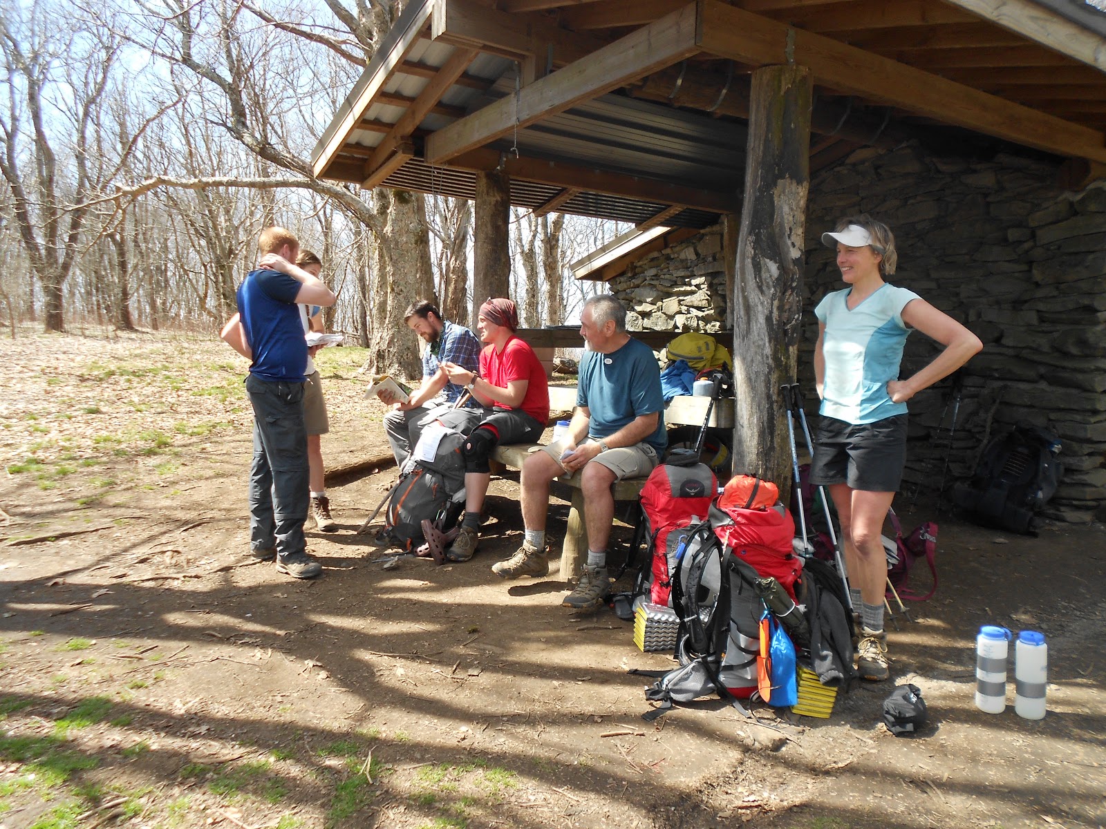
I hiked with this group of young folk for my entire trek (left to right): Grin, Pippin, Deniro, The Machine (Mac), BadAss, Roadrunner. In short order they became trail-buddies and I enjoyed getting to know each one of then over the following days as we congregated each night at the next shelter. If you guys see this, I want you to know that you made the trip so special and I hope that I will "See you down the trail, before your hike is complete."
Day 2: This day started with the early departure of a delightful pair of thru-hikers closer to my age than the others. They were planning on hiking some serious miles so I knew I would not see them again. Such are the whims of the trail and its travelers.

It was light by 7:00a and I was out my 8:00 to give myself plenty of time to hike the 12 miles to Derrick Knob. The terrain was much more difficult than the topo map showed so at times it was slow going for me. It was starting to cloud up and became even more windy than the day before since I was hiking along the mountain ridge, often exposed on both sides of the mountain. A few miles outside of the shelter on a steep downhill I planted my left leg and as I lowered myself down I felt something in my knee crunch and then every step thereafter was painful. O crap! I had something similar happen to my right knee when The Boy and I were hiking at the Philmont Scout Ranch in New Mexico many years ago and since then I have had some pain going down hill with a heavy pack. Recently I had begun to use one of those elastic knee braces and since then experienced no pain in the right knee going down. So I switched the brace to the left and hobbled on down to the shelter arriving about 4:30 just before the rain commenced in earnest. Without going into details I knew this was going to be a problem; I just did not know how much at this point. The Gang of Six was already in place, and the shelter was filling fast. I staked out my claim on the top shelf while the fire-builders warmed the shelter with their efforts in the interior fireplace. Because of the cold and windy conditions all the shelters were outfitted with tarps across the normally open face: thank you trail volunteers. We sat around trying to stay warm; that kilt did not keep out the breeze and I had decided I did not need to bring my leggings due a clement weather forecast (bad choice, never believe those). If I sat for more than a few minutes my knee would stiffen considerably and scream at any attempts to move it. Fortunately there was no swelling or bruising. Seventeen people ended up in a shelter build for 12; cozy and close as it was it was a quiet night in the shelter, and morning reports were that most slept well. I woke myself several times when I turned and the knee spoke to me. The days hike had taken it toll on everyone even the most conditioned.


Day 3: Woke up pretty stiff and with 13.5 miles to go, a knee to test, and an ascent to the highest point on the entire AT (Clingman's Dome 6600 feet), I wanted to get out early. So, no cooked breakfast, just some trail bars along the path. The day was near perfect for hiking, with partly cloudy skies, still a bit breezy but warmer and the trail had started to dry out a bit from the night before. The knee was worrisome because it changed the way I hiked: going uphill was just uncomfortable and my hips were hurting more than the knee, but much less than earlier with larger doses of ibuprofen and acetaminophen. I could make good time on relatively level terrain so I pushed myself when I could, but downhill was tough. Fortunately, the right knee without the brace was just fine, not a hint of discomfort and with my hiking sticks and some peg-legging (flexing that left knee with weight was not a good idea), where possible, I made it to the top of Clingman's Dome no worse for wear. Many of my hiking companions came in a bit after me since I had started so early. After lunch at about 2:00p I had four more downhill miles to go before reaching the Mount Collins Shelter, which ended up being torturous. I was enjoying being on the trail and the views as you can see were spectacular given the bareness of the trees and the clarity of the air (not so smoky), but when I started to consider what was ahead in the next 3 days I was feeling very uncertain about what to do. I knew that were some serious up and downs coming with more miles to cover per day than so far. Considering options was unavoidable. The shelter was a bit crowded but we all packed in and had a lovely and early evening. Once it starts to get dark, the shelter quiets and sleeping bags are full of tired bodies.


Night 3: Now was the time to study my maps and assess the terrain I was facing. Four more miles down the trail is Newfound Gap where TN Rt. 441, which is the cross-park connector between Gatlinburg and Cherokee that provides access to the outside world. East of there, where I was heading is nothing but wilderness with no road access for 30 miles. That next road access is the bottom of the Pigeon River Gap which is a downhill from 5000 feet to 1500 feet and then an ascent back up to 4200 feet. The next two days would have been 15 miles, then 13 miles over a little easier terrain, but the next to last day required me to hike 18 miles down into that aforementioned gap and back out. My options were these: try to stay on pace to make it to Max Patch in four days and meet my ride; hike to Pigeon River and come off the trail there a day early; hike the 4 miles to Newfound Gap and catch a ride back to Asheville. My concern was not that I could not finish the hike, it was that I could not finish on schedule. Since I had tight parameters on the trip, I either had to hike on schedule or quit. I did feel I had the option of just slowing down (as a thru-hiker would), taking a couple of more days and trying to recoup while hiking. Disappointed as I would be I decided to play a conservative hand and leave the trail. Not knowing exactly what was wrong with my knee and knowing that staying on pace would be some of the most difficult hiking I have encountered so thus far conspired against me. So with that decision made I snuggled down into my warm cocoon for a more restful sleep.
Day 4: Knowing that I only had four miles to go today, I took my time getting up and packed, seeing off all my newfound friends and wondering if I would see them again. Thor and Happy-Grumpy were taking it slower today so we spent some meaningful time just hanging out at the shelter. We headed out together a little before 10:00a, in no real hurry to get to the gap. The day was glorious. The trail was mostly downhill so we took it slow and arrived about 12:00 noon. Many of our shelter-mates were hanging out there; one of their number had hitched a ride down to Gatlinburg with the idea of bringing back 30 hamburgers (that's 5 per hiker in that group). A hiker shuttle showed up not too much later and after a few farewells a group of us went down the mountain, out of the park and into Gatlinburg. I called family in Asheville and they made the two hour trip over to pick me up in the afternoon. So instead of 90 miles I hiked 40; I was disappointed but relieved, knowing I would have the opportunity to come back and finish under different circumstances.
Reflections: At least one time before I placed some rigid bookends on a hike and found myself under stress that hikers go to the trail to avoid, so, if I am true to my word, I will not plan another hike that does not have some slack time for delays. I now have a pretty good idea of what I can do physically given the terrain of a hike and will be better equipped to plan a hike that matches my capabilities. At my age, 63, I will probably continue to be a bit conservative when I sustain some injury or pain (other than normal soreness from serious exertion). The last thing I want (which was especially the case on this hike) is to find myself incapacitated on the trail and in need of Herculean efforts on the part of my hiking companions or rescue personnel to get me out and jeopardize their health and safety. I loved the Smokies and understand why it is the most popular National Park in the nation.
OrthoVisit: on my return I went to a local ortho sports urgent care facility. Looks like a torn meniscus in my left knee and bursitis around my hips, in particular the long muscle-tendon group that runs over all the stuff around the hip and down the leg, an inflammation common to long-distance hikers. The good news is that the knee damage is probably not severe and may work itself out like my right knee did without surgery. Rest and steriods for a couple of weeks should do the trick and next time out I will be packing plenty of naproxen, the best anti-inflammatory for hikers according the shelter lore.
What's next? I hope to be back on the trail in May after a wedding in Alabama. M is going to drop me off in Damascus, VA during their trail festival (lots of thru-hikers) and I will hike north on a loose schedule and, if I do well, I may find myself finishing in Pearisburg, 150 miles from the drop off. Otherwise, I will go as far as seems reasonable and have M come down the valley of Virginia and pick me up wherever of come off the trail.
 |
| Ready to go |
 |
| AT NoBo Entrance to GSMNP |
 |
| Fontana Dam |
 |
| I really an doing this; no joke |
 |
| Dam backwater |
 |
| wildflowers |
 |
| Is that snow? No, a blanket of wildflowers. |
 |
| Mollie's Ridge Cooking Area |
 |
| Happy-Grumpy at back, Thor on right |
 |
| Gang of Six |
 |
| Good tent spot for T & HG |
 |
| Gear abounds |
 |
| Room for 12 |
 |
| Closed up for the evening |

 |
| Beautiful Start |

360 degree view
 |
| Wildflower combo |

Deniro's quest
 |
| Crowded top layer |
 |
| Old guy among the youth |
 |
| Ridge line mist |
 |
| Clearing up |
 |
| Need a shelf? |
 |
| See that snowbird? They were bountiful. |

 |
| Trail Angels: Rising Dawn and Trekker Nice folks but they were out of stuff. |
 |
| Higher elevation evergreens |
 |
| Is that Clingman's? Must be a tease. |
 |
| Viewing tower on top of Clingman's |
 |
| Friendly snowbird looking for a handout in Clingman's Tower |
A spin around Clingman's Tower


 |
| Late dinner for Thor, Happy-Grumpy, and Hank |
Day 4: Knowing that I only had four miles to go today, I took my time getting up and packed, seeing off all my newfound friends and wondering if I would see them again. Thor and Happy-Grumpy were taking it slower today so we spent some meaningful time just hanging out at the shelter. We headed out together a little before 10:00a, in no real hurry to get to the gap. The day was glorious. The trail was mostly downhill so we took it slow and arrived about 12:00 noon. Many of our shelter-mates were hanging out there; one of their number had hitched a ride down to Gatlinburg with the idea of bringing back 30 hamburgers (that's 5 per hiker in that group). A hiker shuttle showed up not too much later and after a few farewells a group of us went down the mountain, out of the park and into Gatlinburg. I called family in Asheville and they made the two hour trip over to pick me up in the afternoon. So instead of 90 miles I hiked 40; I was disappointed but relieved, knowing I would have the opportunity to come back and finish under different circumstances.
 |
| Good Companions |
OrthoVisit: on my return I went to a local ortho sports urgent care facility. Looks like a torn meniscus in my left knee and bursitis around my hips, in particular the long muscle-tendon group that runs over all the stuff around the hip and down the leg, an inflammation common to long-distance hikers. The good news is that the knee damage is probably not severe and may work itself out like my right knee did without surgery. Rest and steriods for a couple of weeks should do the trick and next time out I will be packing plenty of naproxen, the best anti-inflammatory for hikers according the shelter lore.
What's next? I hope to be back on the trail in May after a wedding in Alabama. M is going to drop me off in Damascus, VA during their trail festival (lots of thru-hikers) and I will hike north on a loose schedule and, if I do well, I may find myself finishing in Pearisburg, 150 miles from the drop off. Otherwise, I will go as far as seems reasonable and have M come down the valley of Virginia and pick me up wherever of come off the trail.