When: August 25 - 28, 2014 Where US 19E near Roan Mountain, TN to Indian Grave Gap, TN 395 Weather: 4 days of perfect weather, a bit cool the first two nights, no rain. Length: 42 miles southbound Elevation Changes: US 19E trailhead, 2897; Hump Mtn., 5587; Overmountain Shelter, 4654; Round Bald, 5826; Carver's Gap, 5512; Toll House Gap, 6217; Roan High Knob Shelter, 6285; Hughes Gap, 4040; Cherry Gap Shelter, 4012; Unaka Mtn., 5180, Indian Grave Gap, 3350. The accumulated ascent was 12,600 feet. So glad to be back on the trail after a long hiatus. Still tending home fires and, O by the way, home is now in Orange, VA. We sold and moved from our house of 31 years in the West End of Richmond, VA to the house my mom and dad lived in until they passed on. The move adventure is worth a separate blog post, but I am not sure I can do it right now, tender feelings and all. That adventure alone took up most all the time since my last outing. M planned to visit her mom in Asheville, NC and there is still a section of trail east of there toward Damascus,VA that I have not hiked. I chose a 42 mile section with good trail access. M dropped me off on Monday on the way there and picked me up on Thursday for the ride home.. Day 1: Since I was starting at about 1:00 pm, I planned to hike 9.2 miles to the Overmountain Shelter, which started with a significant ascent out of the gap at US 19E. I was soon up on the ridge that runs along the Roan Mountain massif, one of the longest chains of grassy balds on the planet (20 miles). With temperatures in the 70s on the ridge, the afternoon was extremely pleasant and I found myself into the shelter around 5:00 pm, a good pace for the first day out in months. There were very few people on the trail, so I expected I may spend the night in the shelter solo, but as I approached I heard the voices of Erica and Brian, a young couple from NJ, collecting firewood. They were accompanied by man's-best-friend Bruiser and were staying in the shelter as well. Conversation flowed around the campfire and into the evening, very sociable they were. Two other guys (quite experienced backpackers) showed a bit later and camped in a meadow just below the shelter, but their enthusiasm for being under the stars resulted in a soggy morning due to the massive dew; it might as well have rained on them.
Geology revealed
Afternoon view
Trail weaves across NC and TN border
One of many bald walks
Loads of mountain ridges to spy
Wildflowers at elevation
No lack of color
Some history
Delightful preview of shelter
Barn converted to shelter
View of Roaring Creek Valley from shelter
My gear spread out on platform
Bruiser, Brian, and Erica
Day 2: With only 7 miles to Roan High Top Shelter, I took a leisurely morning with coffee and cooked breakfast (freeze-dried breakfast skillet by Mountain House comes recommended) and socialized with the couple. I did plan on roaming the peaks near Roan High Top, so I wanted to leave some time. I strolled across the bald leading up to the peaks and near the top found myself in a dense spruce forest. Experiencing the change from hardwoods with a leaf strewn floor to the cool freshness of the evergreens was exhilarating. The fallen needles created a soft walking bed bordered by a few ferns. I walked past the shelter inadvertently (only a single post on the left, no signboard) and encountered an old chimney, a sure sign I had gone past. No problem since I had planned to go up anyway. I did experience some mild anxiety regarding stowing my pack while investigating. I thought at first I might leave it at the shelter but since I missed it I figured I would just find a place in the saddle between the two peaks at the top. There was public access at Toll House Gap with first-class restroom facilities: running water and a flush. I availed myself of a mini-wash down. I placed my pack behind a tree behind the restroom building and high-tailed it up to Roan High Bluff, all the way a little worried about what I would do if on my return, no pack in sight. The view from the well-developed bluff overlook (wood framed deck and railing) was worth the extra couple of miles on today's hike. There were many day hikers out today from Carver's Gap enjoying another sunny day with mild temperatures and low humidity. I retrieved my pack and headed back down the mile or so to the shelter and set myself up inside the log cabin with loft. I suspected this would be a mouse hotel, but I had decided not to bring my tent, so I would just have to deal. It was still just late afternoon, so I settled into my reading material (a re-read of C. S. Lewis's Chronicles of Narnia). Chris arrived a bit later, we chatted a bit and he decided to tent above the shelter. He departed and I did not see him again (must have been that eau de trail scent that surrounded me). I cooked up my dinner, another Mountain House meal, and settled into the shelter at hiker midnight (about 8:30 pm it got pretty dark). I did hang all my food and odor producing item in a bag from a tree outside, but the mice were determined to check out anything still in the shelter in hopes of a feast. One of them left me a souvenir in my white plastic drinking cup. On summer hikes I usually leave the zero-degree sleeping bag at home and carry a polyester fleece sleep sack M made for me, but with the mild weather and expected nighttime temps I opted for the warm bag - good idea. Around 11:30pm I heard some commotion outside (bear?) but the lights flashing through the door gaps indicated human presence. I opened up and found a youngish pack-laden couple taking the lie of the land. After a greeting and a welcome to the shelter if they so desired they opted for their tent. They did some food prep on the shelf outside, but I went right back to sleep with no bother. I expect they also knew too well that mice were in charge of this shelter. I may need to consider another approach to shelter use.
Panoramic View from Jane Bald
Marvelous Views from here
Spruce take over
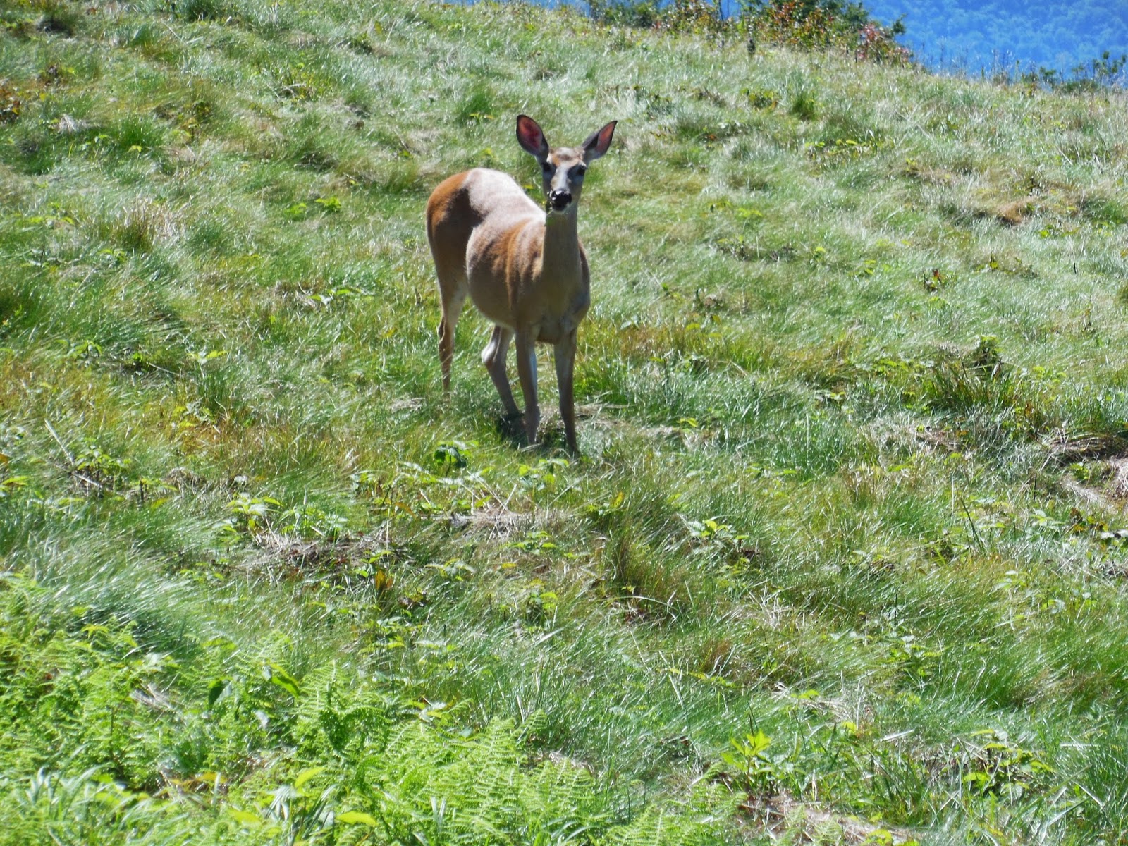
Not so timid doe
Gear inside cabin/shelter
Quaint but mousy
View from Roan High Bluff overlook
Day 3: In order to stay on my 4 day, 3 night schedule I needed to hike 16 miles today. This meant about 8 hours of hiking not accounting for longer rest periods. I had a good plan because the trail followed a ridge with minimum elevation change. I was up before daylight and consumed a protein bar breakfast so that as soon as there was enough light I could head out. The day passed uneventfully among hardwoods with few views (I am beyond the bald stretch). I did take several substantial rests in order to resist the temptation to just pound out the miles as fast as I could to get to the shelter. Near the end of the day I encountered three day hikers, but otherwise no human contact. I did have one good view at Little Rock Knob; I forget how extensive these mountains are, ridge beyond ridge beyond ridge. I arrived at the shelter about 4:00p feeling good but tired and settled in for a night with no visitors. I had experienced no foot problems at all so far thanks to my latest version of foot care: well ventilated trail runners (no Gore-Tex), REI liner socks (thin), no fancy inserts (take up space swelling feet need), and probably most significant, a Vaseline lube job (no friction allowed). The mice in this shelter were bold and they scurried about the rafters in plain sight. I hung my bag outside as usual but they would not settle down making for a less than normal rest. They never bothered me or my stuff directly but the scratching noise of their movements was most distracting. Did I say I was going to have to revisit my shelter use strategy?
Clyde Smith Shelter, very old school, good lunch stop, great water
More color
Very pleasant footpath along the ridge
Gear in Cherry Gap Shelter, block and concrete, wooden platform
Minimal and satisfactory
View from Little Rock Knob
Day 4: I repeated my routine from the day before in order to get out as early as possible for an 11:30a rendezvous with M at Indian Grave Gap. As I ascended Unaka Mountain, elev. 5180 feet, I again experienced the transition from hardwood to evergreen forest, culminating in a dense spruce forest on top. The day was a bit warmer but still amazingly pleasant for what one could expect this time of year. At Beauty Spot, a clearing south of Unaka, I encountered some trail marking frisson. The trail led up to a grassy area, the last of the hike, and was well-marked with painted rocks and steel fence posts painted with white at the top similar to the white blazes on trees along the trail. There was a cross trail at the top to a parking lot so day visitors could catch the view. I encountered a half dozen folk, rested a bit, since I was on good pace to meet M, and then headed across the knoll to the downside. After walking about 0.3 of a mile I realized that there were no traditional trail markings: no painted rocks, or blazed posts within sight. I realize time and time again how dependent I have become on the system of blazes, to the extent that the lack thereof can cause anxiety once noticed. I thought I would go a bit farther, but since there was just high grass I could see that there were no posts ahead of me with a forest looming close. I bailed, turned around and hiked back up to the top, walked down to the parking lot, checked the trail at the top opposite the parking lot and then concluded using logic that the trail I was on had to be the AT regardless of the lack of markings. There was a stone with a blaze right at the intersection and then I noticed a small mad-made pile of rocks, a cairn, just ahead of me on the right. OK, I got to go and if this is not it I will find out sooner or later. About a 100 yards down the trail I noticed a flat rock on the right side of the trail with a white blaze nearly covered with grass; no wonder I missed it the first time. Frisson vanquished, I proceeded with confidence across the rest of the grassy area and into the woods for my final descent into Indian Grave Gap. Thinking I had lost a significant amount of time, the urge to push harder or faster downhill was present but again I resisted, knowing that if I missed the rendezvous I could probably text M and let her know I would be a bit late. As it turned out the trail down was well-designed and I walked it enjoyably and arrived with 15 minutes to spare, enough time to remove my sweat soaked shirt, kilt and underpinnings, as well as my foot gear in place of some camp shorts and a clean tee-shirt with the hope that M could tolerate hiker scent for the ride home. She arrived on schedule and off we went.
Who dat?
Mixed forest
Threshold of dense spruce grove on top of Unaka
In the grove and well-marked
Last bald near Beauty Spot
Reflections: The Roan Mountain hike is one of the most unusual of the entire southern part of the trail I have experienced. Being able to walk along wide open spaces for significant distances and see expansive views (it was also unusually clear) as opposed to hiking in a tunnel or under a canopy is a welcome difference. The only other evergreen sections I have hiked were in the Smokies, so this was a treat.
I have refined my gear to the point that hike preparation is routine and my pack weight this time with 2 liters of water and food was about 20 pounds, an easy load and just about right for the time out. Hiking with as light a pack as possible brings many benefits, but there are trade-offs. The idea of using the shelters and leaving the tent at home is fine; there are usually enough shelters along the trail to accommodate reasonable daily distances, but it is limiting in that there are many good campsites with water resources along the trail (more than shelters) that could be used at day's end. Sleeping in the open is not really an acceptable option, at least for me. Many long-distance hikers will use a combination of shelters and campsites depending on how much they desire to hike in a given day. They will start out with a goal in mind (or maybe not) and hike through the day and see how they are progressing. Often I have been at a shelter early in the day and hikers will drop in for water or a rest and then strike out again just to add another 5 or so miles before calling it a day. Having your tent allows for this flexibility. Also, tenting at a shelter (there are usually camping spots in the same vicinity) provides some level of separation from fellow hikers and their habits (some not so good) as well as the sounds they can make at night when asleep, so you can have the social experience around a meal and the campfire but find solitude in sleep. Mice seem to congregate at shelters for obvious reasons, and if one does a good job of hanging stuff with smells that attract vermin, there is a low probability that they will be interested in what is in your tent. Next time out, I am taking my tent - worth a little more weight.
I missed the AT thru-hiker culture this time out, which changes the experience. There is just something remarkable about the people you meet who are willing to accept the challenge of long-distance backpacking.
I have 75 miles to finish the section to Damascus, VA. I hope to finish that this year, hiker companionship or not. With that I would have hiked from Fontana Dam, NC (south entrance to the Smokies) to Mt Holly Springs, PA (50 miles of trail north of the Maryland/PA border) a total of over 900 miles.