
Where: Rt 42, North of Laurel Creek Shelter near Newport, VA to Pearisburg, VA
Length: 40.2 miles (D1 - 8.2, D2 - 12.7, D3 - 19.3)
Elevation: Bounced around 1500' to 4000'; mostly a ridge hike with a few gaps thrown in.
This trek began in September with my friend Conor from Ireland. See previous blog, if you are interested. We had planned on hiking 90 m from Daleville, VA to Pearisburg, VA but after 50 miles I was done. I learned later that I was a bit anemic which explained why I felt so sapped of energy during the hike. Medical speculation suggested I had picked up a virus that chewed up some red blood cells, and along with feeling exhausted, I had lost my appetite so I was running on empty or close to it. My hike ended with Conor lugging my pack for me back down from the Laurel Creek Shelter to Rt. 42, where I caught some rides back to my truck in Daleville. My health improved, but other exigencies conspired to keep me off the trail until last week.
So I had been watching the weather and noticed that the temperature down near Blacksburg was headed toward the 60s for the weekend but there was the threat of snow in VA midweek. Simultaneously, all my girls were planning a trip to Asheville so my 6 month old granddaughter could meet her 93 year-old great-grandmother and other family members in the flesh. The two daughters were coming from NoVA and Baltimore and they would leave from Richmond on Thursday. But late Tuesday night and Wednesday looked like a bad travel period so they came on Tuesday. My 4 girls and I hunkered down and watched the snow on Wednesday because Henrico Co. schools were closed and M had a SNOW DAY. How fortuitous. We had a great time just hanging out for an unplanned day of total relaxation. On Thursday, they headed south and west and I went to Orange to check out Pied-à-Terre. Ouch! Lots of downed wood, enough so that I will need to contract some help to clear it all away. The wet snow had done its pruning work as well as bringing down a tree in the lower 40.
The forecast for snow on Wednesday in central VA had been for 2 to 4 inches and with the balmy weather approaching I expected there would not be too much to deal with. Friday I took off at 6:00a to meet a friend from Blacksburg in Pearsiburg who offered to shuttle me to Rt 42 north of Newport where I ended the last hike and would begin anew. With my truck safely parked near the Food Lion not too far from where the AT comes through Pearsburg, awaiting my arrival, I hit the trail for the first time since September.
Day 1 hiking started at 11:00a and consisted of the 8.2 m from the road past the Laurel Creek Shelter up to about 2500 feet for an overnight at the War Spur Shelter. As I ascended I encountered more snow that I expected and found myself trudging and slipping my way along: an arduous task, not as bad as walking on sand but similar. SNOW DAY. I felt good: plenty of energy, appetite and enthusiasm. I met one thru-hiker headed north (a NoBo) as I header south. He had begun his thru-hike on Jan. 1st in Georgia. This guy became my Reverse Traveling Companion (RTC) since wherever there was snow there were his footprints. I cannot begin to explain how helpful those footprints were to step in when the spread was right and as a marker for where the trail was. Of course, the blazes on trees were in their normal places but, with a blanket of snow in places, sticking to the trail would have been more difficult. More than once I noticed his steps wandered off and then found their way back to the path. I never doubted where the trail was the whole time. Thanks to you, would be thru-hiker #1 (I suspect). I reached the shelter around 4:00p, tired but thrilled I had done so well my first day out in a while.

 |
| Laurel Creek Shelter - lunch spot |


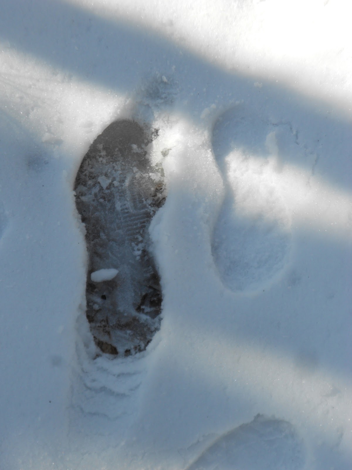 |
| RTC left (size 12+?), Hank right (size 9) |
 |
| 4 to 6 inches of snow |
You will notice that at times there is snow and then no snow. Elevation, solar exposure and ridge position made significant differences in quantity and texture of snow.
 |
| War Spur Shelter |
Day 2 began with 25 degree temperatures and bright sunshine. Equipment note: that zero degree sleeping bag from Campmor did the trick, snug as a bug in a rug. There rest of my gear was well suited for the temperature range experienced. I was a little slow getting out but after a good breakfast was on the trail by 8:00a. As I ascended to the 4000 foot ridge I experienced the deepest snow yet and wondered how long the 12 m hike would take. SNOW DAY. I was not worried about how late I would get into the shelter, just what kind of pace I could maintain. I got into Pine Swamp Branch around 3:30p. I encountered a Scout troop headed north at the Bailey Gap Shelter where I was taking lunch. It was 1:30p and they had 8 m to go up to the snow-covered ridge. I wonder how they did (if one of you leaders happens to check this blog, send me an email about how the hike went). The day was much warmer and I shed a layer midday. I still built a fire in the interior fireplace at the shelter. Cozy.

 |
| Scout Troop, most in shadow of shelter |


 |
| Interior of Pine Swamp Branch Shelter w/ fireplace |
Day 3 began earlier; I had a new plan. Since I had made such good time the past two days and was feeling good, I had considered the possibility of finishing the hike on Sunday instead of spreading it out to Monday. Wisdom suggests that one should not put tight bookends on a hike since sometimes taking an extra day can improve a trip. I had done so. This would require I hike 19.2 m, so my test was to see what time I could get into the Rice Field Shelter (where I had planned to overnight) with 6 m left to go. I started just before 7:00a. Even with more snow than I wanted to deal with, SNOW DAY, I made great time and was eating lunch at the shelter at 1:00p


This is my first attempt to post a video. I had a panoramic view from the main ridge north of Rice Field and wanted to see what my little Nikon would do. The beginning is a view west toward WVA, then a shot of the trail, and finally an eastern view. Next time I will make it 360 degrees to give the complete picture.
I loved this shelter, though its placement on the ridge made access to water a 0.3 m trip down the side of the mountain to an unreliable spring I did not want to try. Earlier I had used up all my water (planned but a little unsettling). As I had at times cursed the snow, not too far back on a high part of the ridge, there was a line of crusty snow adjacent to a large felled log. I decided to water up knowing that if I did not have any more water for 10 m thereafter I would be OK. So I perched on the log and lifted off the glazed and icy top layer and bit off fragile mouthfuls that had the perfect consistency to lightly crunch and swallow. I ate until I could not swallow another mouthful. Now I was really ready to hike out.
 |
| Can you see the trail on the opposite rise? |
 |
| Rice Field Shelter w/ stile and privy to left rear |
 |
| View of privy from shelter |
 |
| View of front of privy: airy huh? |
 |
| View from the Throne |
The privy arrangement was clever. It was a newer composting style where no hole is dug and the platform is elevated above the ground. With use, composting materials are added and when the pile gets to a certain size the can is moved, usually shifted from one side of the paltform to the other. After a delightful lunch I headed out to finish in near clear skies and 60 degree temperatures.
 |
| First water since the snow log |
As I was descending into Pearisburg using the run-down-hill technique I observed and practiced with Dan from Georgia last May, I encounter some of the loveliest young ladies one would want to meet. We chatted for a few minutes and I gave them some insight into distances to the Rice Field Shelter and the campsite adjacent to the corrugated pipe spring.
 |
| Wake Forest grad; ASU coed; Wake Forest coed |


After leaving the girls I had about 3 more m to go mostly downhill without much scenery. I came out of the woods and traveled under Rt. 460 where it crosses the New River west of Pearisburg. Up, around, and across the bridge then another mile to a trail intersection near Main Street and a brief jaunt over to the Food Lion and my truck. I headed back to Orange to recheck things and contact my tree guys. Monday now was a day of leisure, where I just chilled in the morning and then headed back to Richmond a day early.
Reflections: I will be a bit more discriminating when it comes to snow on the trail. It's dangerous and if I had known how much was up there and what the path conditions would be I may have chosen not to hike, but as it were, I bested the challenge and it certainly made the trip more interesting (but not pleasurable). I like my gear; I went ultralight: no tent, no extra clothes, minimum water (water up at spring/creek sources and carry only enough so you run out before you get to the next source), balanced food, trail runners (not ankle boots), down bag and 3/4 length thin sleeping pad. This was a great way to start this years hiking; I am planning all my future treks to be at least a week on the trail and over 100 m. I do like hiking with people, but encountered few this time out. Those shelters can be a bit lonely at night. I have now hiked 25% of the AT.