What: A four day camping, hiking experience
When: July 26 - 29, 2019
Where: Crater Lake N.P. (CLNP)
Three years ago, M and I visited CLNP for a day having traveled to the Pacific Northwest to spend time with the boy (see post July 6, 2016). Being early summer the east rim road was closed with snow; pictures from that trip show an abundance of remaining snow. We made a day of it mostly gazing at the lake from a variety of vantages. I checked a box on my bucket list not expecting to return.
This past winter when the family was considering a week-long vacation we decided to all fly out west to where the boy lived in St Helens, OR. We booked flights and reserved an AirBNB in an adjacent town, Scappoose: all set.
Two years ago I made a trip to St Helens soon after the boy moved there with a new job and stayed two weeks (see post November 6, 2017). I requested and received approval to stay an additional two weeks this trip with the boy after the family headed home.
One spring day the boy sent a text to the Micks Clan asking if anyone was interested in Crater Lake. With one week in a new vacation place with plenty to do and see, the group felt that driving the 5 hours each way and arranging accommodations was too much. But that did not deter the boy and me from planning a trip there during my extended stay.
Fast forward to July 13th: we all went out and had a delightful but busy time together, trying to see and do as much as we could and still have good family time. Success. July 20th left me alone after taking a group to the airport and as I headed back to St Helens, four mountain peaks visible on the return: Mt. Hood, Mt. Adams, Mt. St Helens, Mt. Ranier. Paradise.
Before the trip I had been working hard at home and in town, getting ready to be away for three weeks and trying to make some progress on a number of projects hereabout. I needed some rest and downtime. So I spent a good part of the latter part of the trip at the boy's house just hanging out: reading, eating, walking about, going to yoga, reading, reading and spending time, when he was not working, with the boy and his friends. I knew that the upcoming Crater Lake trip was the centerpiece so I was lacking motivation to go off for a day and hike a mountain or two (did that two years ago).
Crater Lake NP Trip
Day One
We planned to camp at the Lost Creek Campground inside the park. There are 16 primitive sites (no water, no electricity, port-a-johns) available on a first-come-first-served basis. I was a bit anxious about this arrangement, knowing this was the busy season and other options where limited (I thought). So we left at 0-dark-30 and arrived with bright sunny skies and moderate temperatures around 10:00a. We entered via the south entrance to the park and proceeded around East Rim Drive which is only open mid-summer to fall due to snow. Though there were a number of overlooks to stop and view the lake we were not to be deterred from landing an early campsite. Lost Creek Campground is 4 miles south of the Rim Road, off the beaten track, and PTL, there were five open campsites. We made our choice and started setting up. By 11:30a all the sites were filled; good planning and providence. We paid at the self-pay registration kiosk and hung our reservation ticket on the number post of our site (#9). As we walked around the campground we noticed that the majority of campers were here for a one-night stay; people were just passing through to check out the lake, camp, and then head off somewhere else.
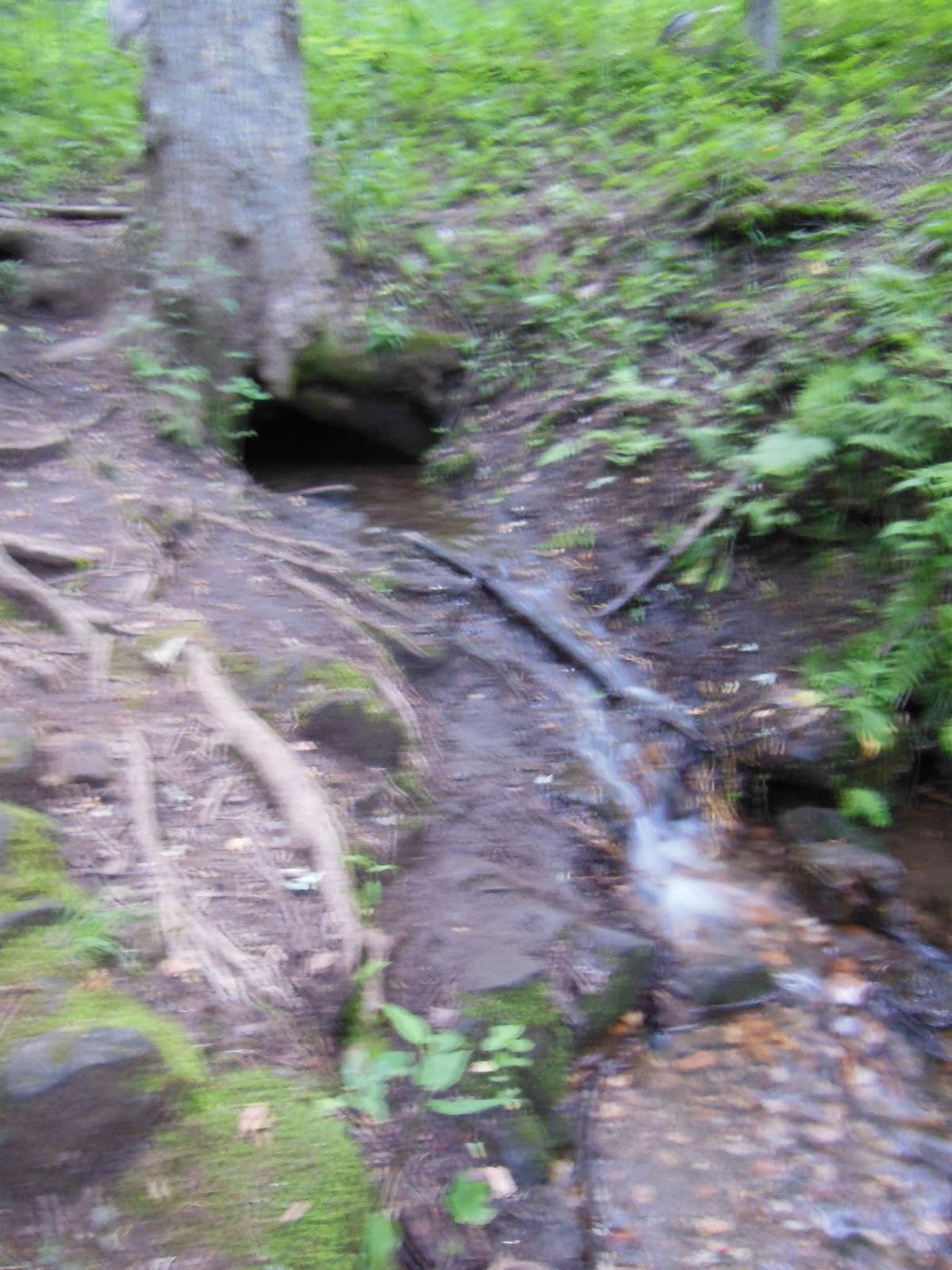
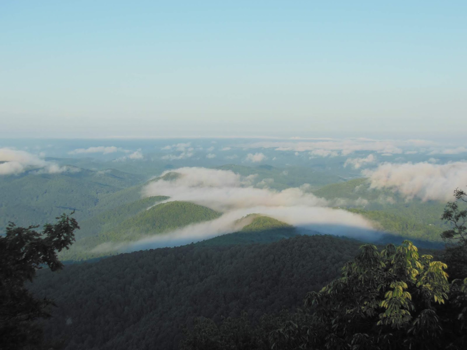
Our first day adventures surrounded getting the lay of the land. We set up next to Lost Creek at a bend in the loop and sorted out stuff on our picnic table while making plans for the day now that we were exuberant with our campsite success; we were now looking forward to four days in the park. We noticed a significant presence of mosquitos and though we had some repellent we put that on the top of our camp store list. We packed a lunch and headed up to the rim road and the additional 10 miles to the Steele Visitor Center, the NP Headquarters, with surrounding maintenance, administrative, and residential buildings. We first stopped at the intersection of the Pinnacles Road and the Rim Road at the Phantom Ship overlook already crowded with cars and tourists. We encountered Lisa, a California based outdoor enthusiast in cycling garb with bike. She was planning to ride the entire Rim Road and wanted our perspective on which direction to make the circle. She was also staying at Lost Creek, so we expected to see her again. Next up was to view the movie at HQ describing the park geological and anthropological history. If you are interested just visit the NP website. Suffice it to say, 7,500 years ago a cataclysmic volcanic event occurred that reduced towering Mt. Mazama to a caldera 5 to 6 miles across at 6,500 feet. This filled with snow and rain and is now the deepest lake in the USA. Further volcanic activity raised a 700 foot island near the north end of the lake named Wizard Island. We shopped a bit and then drove down to Mazama Village near the south park entrance. A large campground with tent and RV sites, a restaurant, and camp store run by concessionaires made for a bustling center of activity which we planned to avoid. Checked the store for sunscreen and insect repellent; struck out on number 2, no surprise in reflection. Putting that behind us we made our way to the Rim Village consisting of a grand hotel, rim walk, another NP gift shop, a concessionaires cafe and gift shop, and other support facilities. Lots of people around and getting busier my the minute. We munched lunch on a wall along the lake and took in its grandeur: pines, slopes, scree slides, snow remnants, and a vast expanse of blue water. We signed up for the Rim Road Trolley Tour scheduled for 10:00a the next day: a two hour round trip of the rim road led by a NP Ranger. Having visited all the facilities we headed back to camp stopping along the way at the Pinnacles, an array of rock formations from the volcanic activity. We ventured down the trail to the park boundary under clear skies and warmer temperatures than expected: high 80s but dry. Once back in camp we prepared our Pasta Sides with tuna packet protein bump on our two-burner propane stove. Meanwhile Lisa, presented herself at our site for a chinwag, just being neighborly. We would encounter her and her traveling partner Holly several more times which enriched our experience. By now the mosquitos were swarming and our repellent reserves were diminishing rapidly. I wandered over to the adjacent campsite and asked a couple how their stock was holding up. Hubby pulled out a small bottle of 100% DEET and squeezed some of the viscous liquid into my recommissioned Costco glass cleaner spray bottle filling it to the top. A couple of drops are dynamite, literally blowing those insects away. All set. As the sun dropped near the horizon so did the temperature and by the time we slipped into our two-man tent it had dropped 20 degrees. Warm sleeping bags a necessity on this trip.
 |
| Just arrived |
 |
| #9 |
 |
| Wizard Island and Lake |
 |
| Phantom Ship |

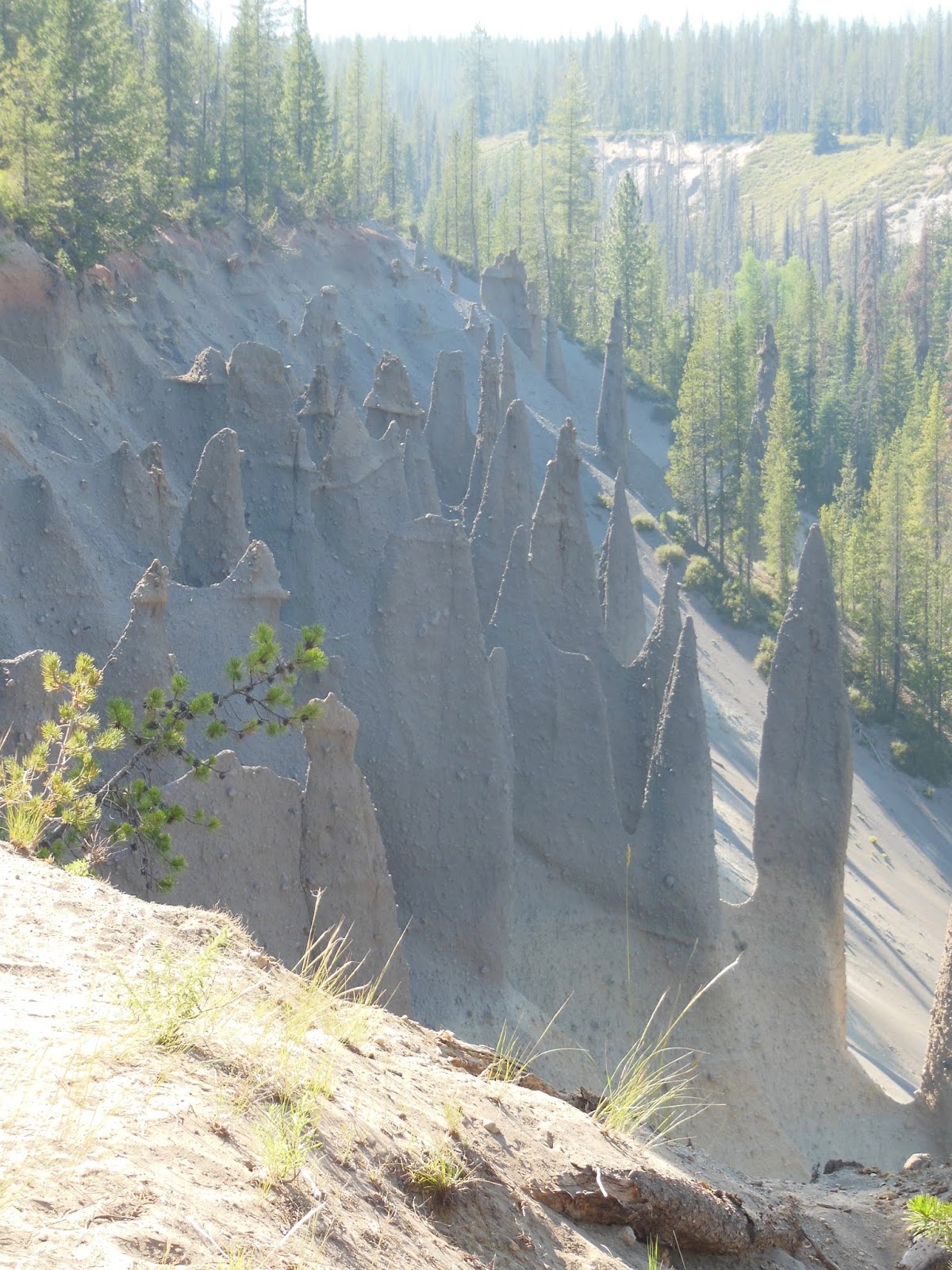 |
| Pinnacles |


Day Two
Up before the sun; chilly temps; frost on the picnic table; hot tea and a book. So quiet. Big plan for today: trolley tour and lake swim. After a snack breakfast, up to the rim for coffee at the cafe (ran into Lisa again and talked about what we were doing today; she was inspired by our plans to swim) and the 10:00a, two hour trolley tour around the entire Rim Road. The experience was like drinking from a firehose; our guide had encyclopedic knowledge combined with a delightful presence and delivery; stops at several inward viewpoints with expansive lake scenes and outward sites of waterfalls and other natural beauty. No chance of explaining the depth and breadth of our tour. Pictures will have to suffice.
After the tour we lunched at the Rim Cafe on their most popular offering: a big hot dog. We now know why it is so popular. Back in our car we headed around the west rim toward the Cleetwood Cove access, where a one mile trail takes you from the rim down into the caldera to the lake level. From here tourists can take a boat out to Wizard Island or find a spot along the rocky shoreline for a swim. The road and parking lot were packed with cars circling and all praying for someone to leave. We decided to make a pass at the parking lot and low-and-behold the boy recognized Lisa's rental with her rowing skull lashed to the top. We greeted her and made arrangements for her and Holly to back out just when we were in position. Go figure: providence? We said our goodbyes since they were leaving the park shortly. We changed into our swimming gear, walked through the mobs of people (this is Saturday) to the trailhead, and started down. At the bottom we passed by the boat dock and the 20 foot high jumping-off-rock over to some less populated rocks and slipped into the bracing and perfectly clear water. There were some shallow rocks at the edge but no more than 10 feet out the bottom plummeted out of view. Near the shore the water was warmer, so after a complete dunk in deeper chillier water we were able to comfortably stretch out half-in-half-out. We sunned for about an hour, chatted with some college kids, and made our way back to the trail. The ascent was classified as strenuous and as I am wont to do I adhered to my "slow and steady wins the race" philosophy to hiking uphill. The boy is of the same religion. Several individuals and groups passed us, some panting and sweating (it was a bit hot). We encountered them again, catching breath alongside the trail never to be seen again. On our return drive we stopped a several overlooks not visited beforehand. Back to camp, mosquitos swarming but at bay, dinner, bed.


Day Three
Today was wildflower and Rim Trail Day. With packed lunch, water and snacks, we headed toward the Watchman Overlook. First stop was Castle Crest Trail, a 0.5 mile loop through a meadow that just happened to be at its peak color, a benefit of coming late July. There were many flowers along Lost Creek as well. We braved the mosquitos, but the boy had not been treated and had on short sleeves. He got hit more than a few times. We then stopped at the Steele Center again to walk the 1.0 mile Lady of the Woods loop trail that meandered through many of the NP HQ buildings. The printed trail guide revealed the history and use of the various dwellings, offices and workshops as well as the namesake stone carving. We learned a bit more about park history and who resides here. On Watchman Peak on the rim is perched an active fire tower rangers use for spotting potential hazards. The tower is actually a stone foundation with a frame upper portion. The rim trail leads up to it a from the overlook and then at a junction proceeds around the rim to Discovery Overlook (traveling widdershins) and back to Rim Village. We hiked up the dusty, sun beaten trail to the fully occupied base of the tower with views on three sides. We could see a ranger in the upper off-limits tower. After lunch and several meaningful conversations with companion scene-viewers, we began our way back to the trail. One surprising thing was the lack of knowledge people had about the area. Having watched the video and experienced the rim tour we found ourselves relative experts to those around us. One PCT hiker dude we came across said something to the effect: wow man, what big effing asteroid made that hole? Nuff said. We did enjoy responding to peoples' questions about things hereabout since we apparently knew the names of geographical features and some history of the place. We encouraged everyone to go the to Steele Center and see the film. The hike on the rim trail was a modest 3 miles, but contained several abrupt changes in altitude which left us puffing a bit and somewhat short of water. The views from the trail, where often you were perched on a non-barricaded sheer drop off, where breath-taking from beauty and fear of tipping over down the slope. Enough to make a mom nervous. We dropped into the next overlook needing a hitch back to the rental at the Watchman and encountered Amanda sitting is her beater just taking in the scene. She said she liked giving people rides. She was definitely an earth child following her wanderlust, leaving the area soon for other places and knowing she needed to see the lake before her departure. We resonated with her and her traveling companion, a friendly, petite black and white canine that jumped into the back seat with me and curled up in my lap for the trip, occasionally sticking her nose up near the open window for that ear-flapping breeze. We made a rest stop at the Rim Cafe for rehydration and a second lunch (we had packed well) in the upper sitting area overlooking the rim, lake, and parking lot. The boy noticed a flurry of red and brown feathers descend into the midst of this crowded area and capture one of those squirrels that look more like a chipmunk. For a good two minutes the hawk stayed calmly put, establishing a secure grasp of its prey before spreading it wings in a demonstration of strength and power when lifting off to awestruck onlookers with photo-snapping mobiles. Nature rules. Our plans for the day concluded with a trip down the Mazama Village to walk two trails there (the boy had it all planned out). To our disappointment all we were able to see where RVs and tent sites, both trails being closed due to hazardous tree falls. We were pretty well burnt anyway from our full day, so returning to camp promised rest and refreshment. By now mosquitos were just part of the landscape, I mean, how long before us has that pest (to us) been living in natural harmony in this wilderness? Food. Bed. Early.
Wildflowers
(Remember that you can click on the photos and go full screen)


 |
| Meadowland beauty |

Watchman and Rim Trail
 |
| Watchman Overlook Panorama |
 |
| Watchman Peak (see the trail?) |
 |
| Trail to Watchman Tower |
 |
| From the tower - Wizard Island behind |
 |
| Mt Thielson to the north |


Day Four
The last day was a short morning in the park. We had accomplished so much that we knew we were ready to head north and we had some commitments late in the afternoon. We were up early, packed, and out just after sunrise. Our last adventure was the Plaikni Falls trail, one mile each way out-and-back through old growth forest and swarming mosquitos to a beautiful waterfall. Worth the trip. Here were the biggest trees we had seen in the park. Our last stop was the Rim Cafe for coffee and egg, sausage, and cheese biscuits, small but tasty. We had plenty of leftover snacks for the trip. As we were gazing one last time over the rim we could smell smoke and the caldera was hazy. We were talking to a lady working the NP gift shop and she said that we were leaving on a good day because there were fires to the south and the prevailing winds were bringing the smoke northward. Apparently the caldera is a natural accumulation spot for smoke due to the vastness of the lake and its cool surface temperature. Incoming visitors were going to be disappointed with the appearance of the lake. Well, that made us the more grateful for the clear skies and ideal temperatures we had experienced for three plus days. Our NP ranger guide on the trolley mentioned and activity with Ponderosa pines. Near the park entrances at lower elevation stand these turtle-barked trees. Stick your nose in close to gaps in the bark and sniff: vanilla or butterscotch? We had planned to do this on the way out, but was told by another ranger that the pines were near the south entrance; we were heading north. O well, you cannot do everything. But wait. We exited the park and turned onto the long, straight road leading to the highway. I was driving and noticed some trees with bark that looked like puzzle pieces or the shell of a turtle. Hey boy! are those Ponderosas? He looked and sure enough we saw them becoming more frequent on the roadside. A quick pullover, flashers blazing, a short walk over to a big one and sniff. Verdict? Two votes for butterscotch; must be genetic. What a wonderful end to an amazing trip.


Reflections
Time with the boy is precious
Who knew about all those mosquitos
Good weather can go a long way to enhancing an out-of-doors experience
Providence never fails: campsite, new friends and parking spots - why doubt?
The wonder of creation brings mystical revelations
Thanks to the National Park Service and all its employees
Thanks to those who had the foresight to advocate for preservation of natural treasures